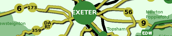
Route eight – Darts Farm via Topsham to Countess Wear Bridge. With return via University sports field and Newcourt Road 7 miles. Thanks to route sponsor Rodney Spiller Wealth Management.
Darts Farm is a family business that began as a pick your own farm shop 50 years ago. Topsham dates from Celtic times, becoming the port of Exeter under the Romans. There are many Dutch style houses from its days as an important cotton port. It became part of the city of Exeter in 1966. The route crosses the Clyst and follows the River Exe east bank to Countess Wear, with good opportunities for bird watching, returning on inland roads and footpaths.
NB: CHECK TIDE TIMES FOR TOPSHAM, AS THE RIVERSIDE PATH IS UNDER WATER AT HIGH TIDE, WHEN THE ALTERNATIVE ROAD OPTION SHOULD BE FOLLOWED
https://exetercosyroutes.files.wordpress.com/2021/05/exeter-cosy-route-eight.pdf
https://connect.garmin.com/modern/course/57362767
Social Media:
Facebook: https://www.facebook.com/exetercosyroutes

Click on above image for 2000x2000 pixel .png
Walking and running Exeter COSY Route 8 by public transport
 There are bus stops in both directions at Darts Farm shopping village.
Clyst St George, opposite Darts Farm – bustimes.org
Clyst St George Darts Farm (E-bound) – bustimes.org

 Topsham Railway Station is 3/4 of a mile from Darts Farm. COSY Route 8 passes close to the station so you may want to continue your walk to Topsham.
Topsham Quay (NE-bound) – bustimes.org
 Darts Farm via Topsham to Countess Wear Bridge - 4 miles
With return via University sports field and Newcourt Road 7 miles. Thanks to route sponsor Rodney Spiller Wealth Management.
Darts Farm is a family business that began as a pick your own farm shop 50 years ago. Topsham dates from Celtic times, becoming the port of Exeter under the Romans. There are many Dutch style houses from its days as an important cotton port. It became part of the city of Exeter in 1966. The route crosses the Clyst and follows the River Exe east bank to Countess Wear, with good opportunities for bird watching, returning on inland roads and footpaths.
NB: CHECK TIDE TIMES FOR TOPSHAM, AS THE RIVERSIDE PATH IS UNDER WATER AT HIGH TIDE, WHEN THE ALTERNATIVE ROAD OPTION SHOULD BE FOLLOWED
https://exetercosyroutes.files.wordpress.com/2021/05/exeter-cosy-route-eight.pdf
https://connect.garmin.com/modern/course/57362767

 There are bus stops near the shops on Glasshouse Lane, and also on Lakeside Avenue and Wear Barton Road
Countess Wear Shops (NE-bound) – bustimes.org
Countess Wear Lakeside Avenue (SE-bound) – bustimes.org


 There are more bus stops in both directions on Topsham Road
Countess Wear Roundabout (NW-bound) – bustimes.org
Countess Wear Roundabout (SE-bound) – bustimes.org
Countess Wear InFocus (NW-bound) – bustimes.org
Countess Wear InFocus (SE-bound) – bustimes.org
 Countess Wear Bridge via Exminster to Marsh Barton - 4 miles
With return along canal bank 6.4 miles. Thanks to route sponsor Haines Watts, Chartered Accountants.
There are a series of bridges near Countess Wear, the original red sandstone bridge was built in 1774, swing and bascule bridges were built in later centuries to span Exeter Canal, which, dating from the 1560s, is one of the country’s oldest canals. The route follows the towpath and footpaths to Exminster, a village dating from the 8th century. There’s a steep climb to high above the motorway, descent to the Devon Motel and into Matford Business Park and Marsh Barton, which has Europe’s largest number of car showrooms. This route finishes at the bridge over the Alphinbrook on Hemyock Road. You can return to Countess Wear Bridge by following the path along the canal.
https://exetercosyroutes.files.wordpress.com/2021/05/exeter-cosy-route-one.pdf
https://connect.garmin.com/modern/course/57365328
 Clyst St Mary via Clyst St George to Darts Farm - 3 miles
With return via Ebford 7.3 miles. This route is available for a business sponsor.
Clyst St Mary was the site of a brutal battle in the 1549 Prayer Book Rebellion. But this is a peaceful route taking footpaths through the housing development Winslade Park, quiet roads to Clyst St George, and on to Darts Farm. Circular return on footpath to Ebford, quiet road looping east of Clyst St George, back to Kenniford Cross and returning on same footpaths to Clyst St Mary.
https://exetercosyroutes.files.wordpress.com/2021/05/exeter-cosy-route-seven.pdf
https://connect.garmin.com/modern/course/57363902
Eight circular routes around the city, making one full 26.2 mile marathon distance.
The Exeter COSY Route project is a community wellbeing and dementia awareness initiative created for Exeter Dementia Action Alliance to signpost people of all abilities to routes on the edge of the city where they can walk and run.
From its roots in an ancient Greek battle to mass participation events around the world, the marathon length of 26.2-miles is a distance that capture’s the imagination. Perfect for Exeter’s unique COSY route – COSY being an acronym for circle of somewhere yours as that’s what it is.
The full circle will take you to every compass and hill viewpoint around Exeter, following footpaths, quiet lanes, field tracks, over stiles, through woodland, paved roads, some busier parts of the city, along its suburban fringe and into neighbouring village communities.
You’ll cross the river and canal, go under and over the M5 motorway, step over both the Exeter to London rail lines, and pass churches, pubs, schools, and local businesses.
Whether you take on this challenge over months, weeks, days or in one strenuous go, you’ll see the city as never before, and complete a marathon in doing so.
https://exetercosyroutes.wordpress.com/