

The Moon is the second brightest object in our sky. It can be visible in the day or night in its month-long journey around the Earth. It is the most recognisable object in the night sky and perhaps the easiest to observe. Features on the Moon, such as the darker rock of the 'seas' can be seen with the naked eye. Binoculars will show craters and mountains, telescopes will show smaller features. The brightness of the Moon makes it an easy object to photograph.
Viewed from the Earth, the Moon travels across the sky near to the path of the Sun. The Sun's path is called the ecliptic and is marked by the constellations of the zodiac. The first quarter Moon rises 6 hours after the Sun, the full Moon 12 hours after the Sun, and the third quarter Moon rises 6 hours before the sun.
Solar and Lunar eclipses can only occur at new Moon or Full Moon. They do not occur every new or full Moon because the path of the Moon's orbit around the Earth is 5 degrees different from the path of the Sun.
- Hits: 1253
Trinity Hill is a substantial area of lowland heath in the east of the district. From the car park a network of footpaths allow easy exploration of this beautiful nature reserve which extends either side of Trinity Hill Road. To the west, Trinity Hill has breathtaking views across the Axe Valley towards the town of Axminster. The site is being managed to support a wide range of wildlife and to restore a structurally diverse heathland landscape.
During the day, moths lie-up in the heathers waiting for nightfall. The heath supports a vast number of different moths, some with beautiful or odd names such as True Lovers Knot, Peppered Moth or the Drinker.
Patches of bare, sandy soil warm very quickly in the sun and attract animals that require heat, like common lizards.
Look out for Linnets singing from tall shrubs on the heath in the late summer. This bird is doing well here although numbers are falling nationally.
In August 2015, Trinity Hill Local Nature Reserve car park was awarded Dark Skies Discovery Site status. This means that it is a great place to go for stargazing because it is away from the worst of any local light pollution, it provide good sight lines of the sky and has good public access.
The nearest bus stop is at The Hunter's Lodge Inn, Raymonds Hill
Social Media:
Facebook: https://www.facebook.com/wildeastdevon/ (3.3k)
Twitter: https://twitter.com/wildeastdevon (3.2k)
Instagram: https://www.instagram.com/wildeastdevon/ (1.7k)
- Hits: 1096
Knapp Copse lies across both sides of a steep valley within the East Devon Area of Outstanding Natural Beauty, and has a true sense of wilderness. There is a rich mosaic of habitats that result in a very attractive landscape once typical of this part of Devon. It includes mature woodland, species-rich grassland, springline mire and a network of hedgerows to offer a home to a wealth of wildlife.
There are a number of attractive walking routes through and around the nature reserve, including the East Devon Way. This long-distance trail runs from Exmouth to Lyme Regis and links with the South West Coast Path at both ends. Two permissive paths through the site link with the East Devon Way, providing a selection of circular walks.
Mature woodland, grazed meadow and springline mire are the predominant features of this site.
In August 2015, Knapp Copse Local Nature Reserve car park was awarded Dark Skies Discovery Site status. This means that it is a great place to go for stargazing, is away from light pollution and has good public access.
Knapp Copse is owned by Devon County Council and managed by Wild East Devon.
https://eastdevon.gov.uk/housing-and-homelessness/community-development/community-orchards/
The nearest bus stop is at the Hare and Hounds, Putts Corner, Sidbury
Social Media:
Facebook: https://www.facebook.com/wildeastdevon/ (3.3k)
Twitter: https://twitter.com/wildeastdevon (3.2k)
Instagram: https://www.instagram.com/wildeastdevon/ (1.7k)
- Hits: 1222
Our most recently planted orchard is fairing well and will be celebrating its third anniversary in March 2020.
https://eastdevon.gov.uk/housing-and-homelessness/community-development/community-orchards/
Social Media:
Facebook: https://facebook.com/SWITCHeastdevon (361)
Twitter: https://twitter.com/switcheastdevon (448)
Instagram: https://www.instagram.com/switcheastdevon/ (164)
- Hits: 1035
This orchard has been embraced by the community and several events take place here each year - including a Blossom celebration. Thanks to the nature of the site and the support of the community this orchard has borne fruit in its first years.
https://eastdevon.gov.uk/housing-and-homelessness/community-development/community-orchards/
Social Media:
Facebook: https://facebook.com/SWITCHeastdevon (361)
Twitter: https://twitter.com/switcheastdevon (448)
Instagram: https://www.instagram.com/switcheastdevon/ (164)
- Hits: 1176
The orchard aims to create a focal point for the community and a habitat for wildlife. The orchard hosts a wassail each January.
https://eastdevon.gov.uk/housing-and-homelessness/community-development/community-orchards/
Social Media:
Facebook: https://facebook.com/SWITCHeastdevon (361)
Twitter: https://twitter.com/switcheastdevon (448)
Instagram: https://www.instagram.com/switcheastdevon/ (164)
- Hits: 1093
Long, dark ridges, deep valleys and dynamic cliffs are the essence of the Blackdowns National Character Area (NCA). The ridges create prominent backdrops from afar and offer far-reaching views. Flat plateaux, large, regular fields and long, straight roads create a sense of openness and uniformity on the ridges. Beech hedgerows and avenues enclose the grazed landscape, although areas of remnant common, lowland heath and scrub still exist, providing open access.
Woodland, much of semi-natural origin, dominates the steep valley tops, creating sinuous dark edges to the ridges; some conifer plantations also exist and intrude onto the plateaux. Below the wooded edge pastoral valleys feature with a medieval field pattern of small, irregular fields bounded by dense species-rich hedgebanks and hedgerow trees, creating an enclosed, tranquil setting. A myriad of springs and streams flow south through the valleys and can often be traced by semi-natural habitats: springline mires, rush pasture and carr woodland. Some valley floors widen and provide an opportunity for arable production, notably the Axe Valley which is characterised by a much wider flood plain. The entire River Axe within the NCA is designated for its biodiversity value, notably lamprey and bullhead fish.
http://publications.naturalengland.org.uk/publication/5233925605556224?category=587130
- Hits: 1219
Axmouth to Lyme Regis Undercliffs NNR is one of the largest and most important active coastal landslip systems in Western Europe. It stretches 7 miles in length, between Axmouth in the west and Lyme Regis in the east.
Main habitats: woodland, lowland grassland, rocky shore, cliffs.
- Hits: 1204
A magical forest on the Killerton estate and one of the largest woods in East Devon.
Ashclyst Forest has a host of waymarked trails for you to explore and experience nature. A haven for butterflies, bluebells, birds and much more.
https://www.nationaltrust.org.uk/ashclyst-forest
Social Media:
Facebook: https://www.facebook.com/Killerton/ (8.8k)
Twitter: https://twitter.com/NTKillerton (6.8k)
- Hits: 1160
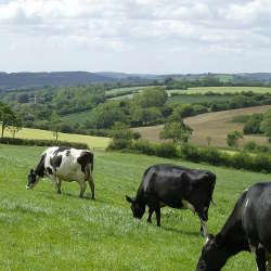
Nestling in a valley that reaches down to the sea on east Devon’s dramatic Jurassic Coast, the village of Branscombe is surrounded by picturesque countryside with miles of tranquil walking through woodland, farmland and beach. Branscombe's charming thatched houses, working forge and restored watermill add to the timeless magic of the place.
An easy graded trail winds up from the beach to the village passing Manor Mill, the Old Bakery tea-room and the working forge. For the more adventurous join the coast path and wander around Beer, once a notorious smuggling centre, or explore eastwards and discover wild dramatic cliffs and steep, green valleys.
Livestock may be grazing the farmland, please keep dogs on a lead. If animals become curious and approach:
- Stay calm and do not run.
- Avoid getting between cows and calves.
- If walking with a dog let go of its lead and meet up with your dog further along the path.
- If animals are blocking the path, whistle, talk or clap which lets them know you are there and encourages them to move. If they are still blocking the way then it may be best to avoid passing them and find an alternative route.
https://www.nationaltrust.org.uk/branscombe
Social Media:
Facebook: https://www.facebook.com/NTEastDevonCountryside/ (1.6k)
- Hits: 1074


