
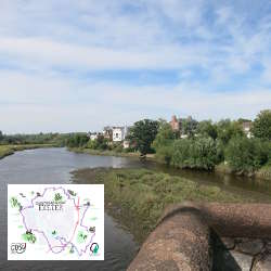
Route six – Blackhorse via Sowton to Clyst St Mary. With return via Bishop’s Court 4.5 miles. Thanks to our route sponsors, the Baker Family.
This route is entirely within East Devon District Council area, the villages of Clyst Honiton, Sowton and Clyst St Mary being Exeter’s closest eastern neighbours. Clyst is a Celtic word meaning clear water and the villages take their name from the River Clyst, a tributary of the Exe. This is a mainly level route along footpaths and quiet lanes to Clyst St Mary. The circular return includes a busier road without pavements and two short, but steep climbs.
NB: Fields on this route are in an area of flood plain, and may be muddy and wet after rainfall, inaccessible in times of heavy rain. There is a difficult stile over the bridge at Clyst St Mary, but an easier alternative is available.
https://exetercosyroutes.files.wordpress.com/2021/05/exeter-cosy-route-six.pdf
https://connect.garmin.com/modern/course/57364003
Social Media:
Facebook: https://www.facebook.com/exetercosyroutes

Click on above image for 2000x2000 pixel .png
Walking and running Exeter COSY Route 6 by public transport

 There are bus stops in both directions at the Black Horse on Honiton Road
Clyst Honiton The Black Horse (E-bound) – bustimes.org
Clyst Honiton The Black Horse (W-bound) – bustimes.org
 Blackhorse via Sowton to Clyst St Mary - 2 miles
With return via Bishop’s Court 4.5 miles. Thanks to our route sponsors, the Baker Family.
This route is entirely within East Devon District Council area, the villages of Clyst Honiton, Sowton and Clyst St Mary being Exeter’s closest eastern neighbours. Clyst is a Celtic word meaning clear water and the villages take their name from the River Clyst, a tributary of the Exe. This is a mainly level route along footpaths and quiet lanes to Clyst St Mary. The circular return includes a busier road without pavements and two short, but steep climbs.
NB: Fields on this route are in an area of flood plain, and may be muddy and wet after rainfall, inaccessible in times of heavy rain. There is a difficult stile over the bridge at Clyst St Mary, but an easier alternative is available.
https://exetercosyroutes.files.wordpress.com/2021/05/exeter-cosy-route-six.pdf
https://connect.garmin.com/modern/course/57364003

 There are bus stops in both directions near the footbridge that crosses the A3052 at Clyst St Mary Primary School
Clyst St Mary, opposite Shelter (E-bound) – bustimes.org
Clyst St Mary Shelter (W-bound) – bustimes.org
 Clyst St Mary via Clyst St George to Darts Farm - 3 miles
With return via Ebford 7.3 miles. Thanks to route sponsor Wilkinson Grant & Co.
Clyst St Mary was the site of a brutal battle in the 1549 Prayer Book Rebellion. But this is a peaceful route taking footpaths through the housing development Winslade Park, quiet roads to Clyst St George, and on to Darts Farm. Circular return on footpath to Ebford, quiet road looping east of Clyst St George, back to Kenniford Cross and returning on same footpaths to Clyst St Mary.
https://exetercosyroutes.files.wordpress.com/2021/05/exeter-cosy-route-seven.pdf
https://connect.garmin.com/modern/course/57363902
 Pinhoe via Pinn Lane, Gipsy Hill and Redhayes Bridge to Blackhorse - 2 miles
With return via Mosshayne Farm 4.5 miles. Thanks to route sponsor Cumberland Grange care home.
Pinhoe is a former village that in 1966 became a suburb of Exeter. It was called Pinnoch in the Domesday book. In recent years it’s seen a huge growth in housing development. There are small shops and refreshment outlets. The route heads over the Waterloo rail line towards the motorway and Redhayes pedestrian and cycle bridge. The circular return is along quiet lanes until the main road back to Pinhoe, which is busy but fully pavemented.
https://exetercosyroutes.files.wordpress.com/2021/05/exeter-cosy-route-five.pdf
https://connect.garmin.com/modern/course/57364337
Eight circular routes around the city, making one full 26.2 mile marathon distance.
The Exeter COSY Route project is a community wellbeing and dementia awareness initiative created for Exeter Dementia Action Alliance to signpost people of all abilities to routes on the edge of the city where they can walk and run.
From its roots in an ancient Greek battle to mass participation events around the world, the marathon length of 26.2-miles is a distance that capture’s the imagination. Perfect for Exeter’s unique COSY route – COSY being an acronym for circle of somewhere yours as that’s what it is.
The full circle will take you to every compass and hill viewpoint around Exeter, following footpaths, quiet lanes, field tracks, over stiles, through woodland, paved roads, some busier parts of the city, along its suburban fringe and into neighbouring village communities.
You’ll cross the river and canal, go under and over the M5 motorway, step over both the Exeter to London rail lines, and pass churches, pubs, schools, and local businesses.
Whether you take on this challenge over months, weeks, days or in one strenuous go, you’ll see the city as never before, and complete a marathon in doing so.
https://exetercosyroutes.wordpress.com/


