
Part of the Exeter Green Circle
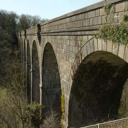
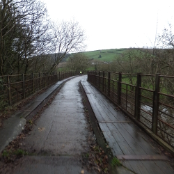
The Redhills Walk is about two and a half miles. It explores the green areas and viewpoints in Redhills and the western fringes of Exeter. There are one or two steep climbs along this route. Notably between the River Exe flood plain, with its allotments and playing fields, and these leafy hills. The Millers Crossing bridge over the Exe is one of the highlights of the walk, especially when the river is high.
Leaflet: https://exeter.gov.uk/media/1051/green-circle-redhills-walk.pdf
- Hits: 1420
Monday to Saturday
Bus Stops: Teignmouth W H Smith (Stop B) - Dawlish Brookdale Terrace (Stop B) - Dawlish Sainsburys (W-bound) - Starcross Opposite Rail Station (Stop B) - Kenton Triangle (NW-bound) - Exminster Royal Oak (W-bound) - Exminster, opp Victory Hall - Exminster Milbury Farm (N-bound) - Marsh Barton Matford P&R (S-bound) - Cowick Stone Lane Retail Park (W-bound) - Exeter Bus Station (Bay 2)
https://bustimes.org/services/2b-prince-charles-road-exminster-dawlish
https://www.stagecoachbus.com/timetables
http://www.stagecoachbus.com/regional-help-and-contact/south-west
Facebook: https://www.facebook.com/StagecoachBus/ (70k)
Twitter: https://twitter.com/StagecoachSW (6.8k)
- Hits: 1823
Whether you are an experienced walker or someone who prefers a short stroll, Exmoor National Park is the ideal place to explore the outdoors on foot. With over 1000km of footpaths and bridleways, through oak woodlands, alongside tumbling rivers and across open heather-covered moorland, the variety is endless. Some of the country's finest long distance routes pass through our National Park, or you can plan your own adventure to explore this unique landscape.
Exmoor Explorers - check out our top ten shorter Exmoor Walks
Long Distance Routes - Some of the UK's finest long distance routes pass through Exmoor National Park. These well planned and waymarked trails are perfect for exploring in sections or as part of a longer walking trip.
Social Media
Facebook: https://www.facebook.com/ExmoorNP (13.7k)
Twitter: https://twitter.com/exmoornp (12.1k)
Pinterest: https://www.pinterest.com/ExmoorNP (136)
YouTube: https://www.youtube.com/channel/UCgUgh9Nu0z80VPO961Z-9tQ (306)
Instagram: https://instagram.com/exmoor_national_park/ (4.4k)
Flickr: https://www.flickr.com/photos/exmoornp/albums (46)
- Hits: 1166
Monday to Saturday
Stops:
Lyme Regis, Rousdon, Colyford, Axmouth, Seaton, Beer, Branscombe, Sidmouth, Sidford, Newton Poppleford, Budleigh Salterton, Littleham
https://avmtbustimes.wixsite.com/mysite/service-899
https://bustimes.org/services/899-lyme-regis-seaton-sidford-sidmouth-budleigh-sa
https://avmtbustimes.wixsite.com/mysite
Facebook: https://www.facebook.com/axevalleyminitravel/ (210)
- Hits: 1972
Read more: 899 - Lyme Regis - Seaton - Sidford - Sidmouth - Budleigh Salterton - Littleham
Do you want to Build Back Greener? Reduce your carbon footprint by swapping to walking and cycling around Holsworthy. Holsworthy is situated on National Cycle Route 3 which follow a cycle path section of the Ruby Way. From Holsworthy you can cycle west to Bude and beyond, or cycle east to join the Tarka Trail at Meeth, or south to join the Pegasus Way at Cookworthy Forest
Traffic free sections are continually being added by Devon County Council as part of their commitment to active travel.
- Hits: 2075
Do you want to Build Back Greener? Reduce your carbon footprint by swapping to walking and cycling around Great Torrington. Great Torrington is situated on National Cycle Routes 3 and 27 which follow the cycle path section of the Tarka Trail. From Great Torrington you can enjoy 30 miles of traffic-free cycling: south to Meeth, or north to Braunton via Bideford and Barnstaple.
Start your journey by hiring a bike from Torrington Cycle Hire at the bottom of Station Hill.
- Hits: 1396
Do you want to Build Back Greener? Reduce your carbon footprint by swapping to walking and cycling around Bideford. Bideford is situated on National Cycle Routes 3 and 27 which follow the cycle path section of the Tarka Trail. From Bideford you can enjoy 30 miles of traffic-free cycling: south to Meeth via Great Torrington, or north to Braunton via Barnstaple.
Start your journey by hiring a bike from Bideford Bicycle Hire in East-the-Water. Continue your journey by buying your own bicycle from Cycles Scuderia in Kingsley Road.
- Hits: 1381
South West Coast Path Association Welcome to the home of the South West Coast Path Association.
We are the charity looking after the UK’s longest and best-loved National Trail. We believe everyone should have access to the South West Coast Path as a place to connect to nature, relax, exercise, and take time away from the stresses of daily life. With the help of our members, fundraisers, volunteers, and partners, we’re protecting and improving the Trail for the benefit of society now and in the future. We hope you enjoy the Path and consider supporting our cause.
https://www.southwestcoastpath.org.uk/
Long Distance Walkers Association Our longest National Trail gives the opportunity to enjoy some of Britain's finest coastal landscapes. These are extremely varied, from rugged and remote clifftops to sheltered estuaries, busy harbours and resorts. Moorland stretches contrast with plateaux incised by steep coastal valleys and intimate coves with long pebbly or sandy beaches.
South Cornwall and Devon offer spectacular 'drowned' estuaries while in East Devon and Dorset there are extensive 'undercliffs' resulting from landslips. Ferries operate across most of the larger estuaries but some offer a reduced service or cease altogether out of the holiday season. Details are available in the South West Coast Path Association's Annual Guide.
Two World Heritage Sites cover sections of the coastline. Mining was a major industry during the 18th and 19th centuries and transformed the Cornwall and West Devon Mining Landscape. This Site comprises ten separate areas both along the coast and inland. The Jurassic Coast is England's only natural World Heritage Site and includes 95 miles of unspoilt cliffs and beaches from Exmouth in East Devon to Old Harry Rocks near Studland Bay in Dorset.
In 2002, Plymouth City Council created a continuous walking route along its coastline and appointed a team of artists to mark the route and interpret the many stories along it. Promoted as Plymouth's Waterfront Walkway (9 miles) this is now part of the South West Coast Path National Trail and is not separately named on OS mapping.
The circular waymarked Dart Valley Trail (17 miles and on OS mapping) connects to the National Trail having the ferry between Dartmouth and Kingswear in common. It also links to the national rail network at Totnes. The Templer Way (18 miles and on OS mapping), which is waymarked except on open moorland, goes between Haytor Quarry and the National Trail at Teignmouth, using the ferry from Shaldon to Teignmouth.
https://ldwa.org.uk/ldp/members/show_path.php?path_name=South+West+Coast+Path+National+Trail
Explore Devon Over the centuries fishermen, coastguards and smugglers have helped to create this historic path – now Britain’s longest National Trail – stretching over 600 miles/960km in total. Ranging from easy to challenging, the path is comprehensively waymarked; the Devon element of the South West Coast Path runs for 90 miles/144km in the north and 115 miles/185km in the south.
This long-distance walking trail boasts some of the most spectacular landscape, seascape, climate and vegetation to be found anywhere in the UK. To the north, the beautiful bay of Combe Martin, Ilfracombe’s picturesque harbour, the magnificent sweep of Saunton Sands and the dramatic cliff scenery around Hartland Point are all inspiring sights. To the south, the coast has many contrasts – from the city of Plymouth to the delightful estuaries of the South Hams; from the many dramatic headlands to the red cliffs of East Devon.
https://www.exploredevon.info/activities/walk/long-walks/south-west-coast-path-2/
- Hits: 1088
Tuesday and Friday
Bus Stops:
Crediton Green (E-bound) - Crediton opp Tesco Metro (Stop B) - Crediton Morrisons (N-bound) - Crediton Barnfield School (NE-bound) - Crediton Morrisons (N-bound) - Crediton Lloyds Bank (W-bound) - Crediton Greenway (W-bound) - Crediton Tuckers Meadow (SE-bound) - Crediton Hospital Gates (W-bound) - Crediton Library (E-bound) - Crediton Willow Walk (NW-bound) - Crediton Morrisons (N-bound) - Fordton, nr Behind Tesco - Crediton Lloyds Bank (W-bound)
https://bustimes.org/services/607-crediton-town-service-circular
https://www.dartline-coaches.co.uk/
Facebook: https://www.facebook.com/Dartline/ (1.1k)
- Hits: 1126
Fridays only
Bus Stops:
Zeal Monachorum Church (SE-bound) - Coleford Gospel Hall (S-bound) - Colebrooke, opp Church - Yeoford The Duck (NE-bound) - Colebrooke Raddon Down Cross (N-bound) - Crediton opp Tesco Metro (Stop B) - Exeter Bus Station (Bay 7)
https://bustimes.org/services/677-zeal-monachorum-exeter
https://www.dartline-coaches.co.uk/
Facebook: https://www.facebook.com/Dartline/ (1.1k)
- Hits: 1210


